

Nature in Iwate
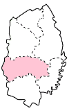
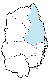
Iwate’s scenic spots can be divided into 6 areas.
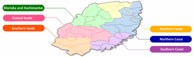
Morioka and Hachimantai
The Kitakami, Shizukuishi, and Nakatsu rivers flow through Morioka City, and Iwate Park is located in the center of town, so the area is also called the “Capital of Forest and Water.”
Mount Iwate, which is sometimes called the Fuji of the North or Nanbu Fuji, looks upon Morioka from the north, its façade changing with the seasons.
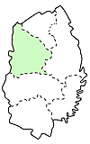
Morioka Castle Site Park (Iwate Park)
There used to be a castle in Morioka which existed as a stronghold for the Nanbu domain a couple of centuries ago, but now all that remains are some ponds and the rock walls that formed its foundation. The park is loved by the city folk and used throughout the year.
Ishiwarizakura, or the Rock-splitting Cherry Tree
Right in front of the Morioka Courthouse is a huge cherry blossom that sprouted from a granite boulder. It blooms every year at the end of April.
Mount Iwate
Mount Iwate has an elevation of 2,038 meters, and is called Nanbu Fuji or the Fuji of the North. It hosts many species of alpine flora, and the mountain is loved by hikers and mountain climbers throughout Japan.
Hachimantai
Hachimantai is a natural stretch of wetlands from Iwate to Akita and is home to many alpine plants. There are also a number of ski slopes and hot springs reports in the area.
Appi Highlands
The Appi Highlands are a 3,500 hectare expanse in latitude 40 degrees, with Mount Appi at its center. The area is rich in alpine flora, wild mountain vegetables, mushrooms, and the forest green tree frog. You can also find Appi Ski Resort, one of the best ski resorts in the prefecture.
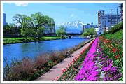
Northern Iwate
The north of Iwate is well-known for being blessed with natural beauty, from the beechwood forest surrounding Mount Oritsume to one of the largest populations of fireflies in Tohoku. It’s also known for being a large producer of Japanese barnyard millet (hie) and foxtail millet (awa).
Hiraniwa Highlands
The Hiraniwa Highlands are at an 800m elevation, surrounding Mount Hiraniwa. They are a prefectural natural park, and you can enjoy nature there all year round.
Mount Oritsume
Mount Oritsume is located at the northernmost point of the Kitakami mountains at an elevation of 852 meters. On clear days from the top of Oritsume, you can see a truly wonderful panorama of the Pacific Ocean, Mount Iwate, and the night sky of Hachinohe City in Aomori.
Basenkyo Canyon
Basenkyo is a gorgeous spot designated as a prefectural natural park. The large sandstone cliffs have been created through water erosion, with both a “male” and “female” cliff overlooking the area as it changes through the seasons.
Central Iwate
The central region of Iwate is home to much of Iwate’s cultural history, from the home of famed author Miyazawa Kenji in Hanamaki City, to the birthplace of the popular folk tale compilation “Legends of Tono (Tono Monogatari)” in Tono City.
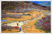
Mount Hayachine
Mount Hayachine has an elevation of 1,917 meters, making it the tallest mountain in the Kitakami mountain range. There are three routes up the mountain, and around 100,000 people climb its peak every year. It was designated a national park in 1982.
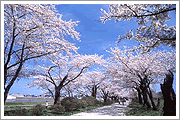
Tenshochi Cherry Blossom Viewing Spot
Tenshochi is a 2km stretch of cherry blossom-lined road on the waterfront of the Kitakami River starting from the base of the Sango Bridge. It was selected as one of the top 100 cherry blossom viewing spots in all of Japan. There are around 10,000 cherry blossom trees and 100,000 azalea bushes that are enjoyed by the people who visit every year.
Lake Tase
Lake Tase is a 45km-long man-made lake formed by damming the Sarugaishi River. The lake is a treasure trove of fresh water fish like koi carp, Japanese crucian carp, and lake smelt, which can be caught in the winter. You can also see iris flowers blooming in the early summer and beautiful nature all year round.
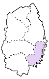
Southern Iwate
The south of Iwate includes the historic city Hiraizumi, which used to be the seat of power and cultural center of all of Tohoku. It is an important historical region rich with cultural heritage, magnificent scenic views, and a collection of important cultural properties and historic sites.
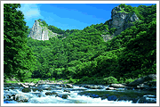
Genbikei Gorge
Midway down the Iwai River is Genbikei, a 2-km-long gorge that is magnificent no matter what the season. In spring, it is covered in cherry blossoms with the water from melting snow flowing down the gorge. In summer, you can enjoy a cool breeze from the river, and autumn sees the turning of the leaves. In winter, the area looks like it was painted in ink upon a white canvas.
Mount Kurikoma
Mount Kurikoma is a peak 1,627 meters tall and is the largest mountain in the Kurikoma National Park. There are routes up the mountain from Iwate, Akita, and Miyagi, with the Iwate path starting from Sukawa Hot Springs resort. Parts of the mountain are dotted with wetlands and lakes, and the mountain is home to many species of indigenous alpine flora.
Geibikei Gorge
The Satetsu River eroded this 2 km-long limestone gorge with 100 meter tall cliffs on both sides. The river flows gently through the canyon, and there are boat rides up and down the river.
Yugendo Cave
Around 1.3km to the north of Geibikei is the Yugando limestone cave. The cave is around 350 million years old, with stalactites jutting from the ceiling to the walls, stalagmites, cave coral, and an emerald green underground lake.
Mount Murone
Mount Murone is a natural wonderland, designated as a national resort and prefectural natural park. The lone mountain looks out across Iwate, with Mount Iwate visible in the distance. The park has an astronomical observatory, camping grounds, and leisure activities.
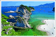
Northern Coast
The northern coast of Iwate contains sights that will take your breath away, including the cliffs that rise 200 meters out of the sea like Kitayamazaki and Unosu. The northern coast is truly the most beautiful coastline in Japan.
Kitayamazaki Cliffs
This 8 km stretch of coast contains large cliffs over 200 meters tall, and is one of the top scenic views of the Rikuchu-Kaigan national park. It is one of those places you have to see at least once in your lifetime, and many visitors come every year.
Jodogahama Beach
Jodogahama is one of the most well-known places of the Rikuchu-Kaigan park. Jodogahama means Pure Land Beach, and was named by the monk Reisho Osho because it looked like the Buddhist pure land heaven had appeared on Earth. Its high-quality water and gentle waves make it a popular beach spot.
Unosu Cliffs
The Unosu cliffs rise 150 meters straight up out of the Pacific Ocean. ooking north from the observatory you can see all five magnificent cliffs jutting upwards, a truly magnificent sight. There is also a walking path along the ocean to enjoy.
Ryusendo Cave
Ryusendo is one of the top three limestone caves of Japan, and is designated as a national natural treasure. The pure spring water that bubbles up from underground forms an underground lake, with the third lake being 98 meters deep, and the 4th lake (not open to the public) reaching an astounding 120 meters deep – the deepest underground lake in Japan. It’s also one of the clearest lakes in the world.
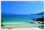
Southern Coast
The southern coast enjoys a gentle climate, and many beach-goers visit in summer. It’s famous for its national scenic spots like the Takata-matsubara pine forest and the Namiita coast.
Takata-matsubara Pine Forest
Takata-matsubara was a popular beach that arched from the mouth of the Kesen River to the Hirota Bay. There was a 2km long stretch of 70,000 pine trees, which had been standing for more than three centuries. Along with swimming, the beach was also a place for wind surfing, yacht, and sea kayaking.
The forest was destroyed by the 2011 tsunami, but a single pine tree remained – the miraculous lone pine tree. It stands as a symbol for the tenacity of the Iwate people.
Namiita Coast
An 800 long beach that contains a rare phenomenon – waves come in without any undertow back out to sea. It’s a popular swimming spot with white sand, pine trees, and a clear blue ocean.
Anatoshiso Rocks
The Anatoshiso is a large rock with three oddly-shaped outcroppings that were formed by the erosion of the sea. It is a famous spot of the Goishi coast.
Rokando Cave
Inside of this limestone cave is a waterfall falling from a huge crack in the crystalline limestone overhead. This is the tallest subterranean waterfall in Japan, at 29m tall and 1m wide. The echo of the waterfall reverberates through the dome-shaped cave.
このページに関するお問い合わせ
Office of International Affairs, Department of Homeland Promotion
(020-8570) 10-1 Uchimaru, Morioka City, Iwate Prefecture, JAPAN
Phone number:019-629-5765 Facsimile:019-629-5254
You can access our question form here.